**
Gibraltar was constantly under surveillance and besieged on several occasions (1727, 1779-1783) without much success by the Spanish armies. The English, stronger than ever, initiated an expansionist policy, encroaching on the isthmus, which was not contemplated in the Treaty of Utrecht. Faced with this fact, the Spanish government made a decision that would be fundamental in the history of the future of La Línea de la Concepción: the construction of a strong fortress, Línea de Contravalación or Línea de Gibraltar.
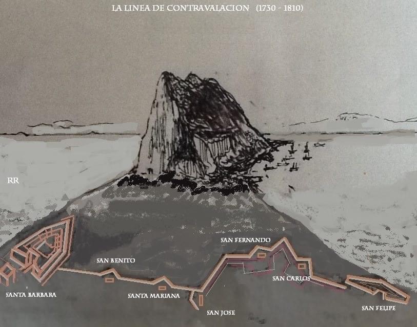
This order was given on November 2, 1730, to the Director of Engineers, Isidro Próspero de Verboom, for the construction of two forts, one located to the east and the other to the west of the isthmus, both connected by a line of fortifications. The purpose was to prevent transit and assert Spanish rights over the isthmus, as well as to make the Spanish presence in the area visible, prohibiting English ships from docking outside the port of Gibraltar.
In 1731, the construction of the two large forts began, named Santa Bárbara and San Felipe. The first was named after the Patron Saint of the Artillery Corps and was located on the eastern beach, with its remains still visible. The second was named after King Felipe V and was located on the western beach.
Between these two forts, a large central wall with several diamond-shaped artillery platforms and their respective guardhouses were built, running from Santa Bárbara to San Felipe. They were all situated at an equidistant distance and were named Santa Mariana, San Benito, semi-artillery platform, and guardhouse of San José, San Fernando, and San Carlos.
Construction of this formidable defensive line with all its bastions was completed in 1735: the so-called Línea de Contravalación or Línea de Gibraltar.
So, in its origins, La Línea was nothing more than a kind of "provisional" camp formed by artisans and merchants who supplied the military and their families near the fortifications built to besiege Gibraltar. Due to being a territory in conflict, the settlement of a stable civilian population was not authorised. The fortresses of La Línea de Gibraltar would remain intact for twenty years, fulfilling the purpose for which it was built. In the early 19th century, the Iberian Peninsula was invaded by French troops. Spain had signed a defence pact with England to fight against the French in the Spanish War of Independence. With the pretext of fearing that Napoleon Bonaparte's troops, which had already reached the Campo de Gibraltar region, would take possession of this fortified line, the Spanish agreed to allow Colonel British engineer Holloway, head of engineers in the garrison of Gibraltar, to demolish the Spanish fortifications and the batteries around them, proceeding to blow them up on February 14, 1810.
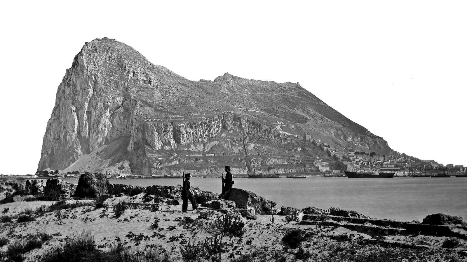
After the destruction of the physical line that blocked passage through the isthmus, the city continued to grow with a strong dependence on Gibraltar, as it supplied all the needs of the British colony (food supply: meat, fruits, vegetables, and vegetables, recreation, and entertainment, physical space for the nearby accommodation of an abundant workforce at the service of an expanding Empire, etc.).
It was on January 17, 1870, when the segregation of La Línea from the City Council of San Roque was authorised, and it was granted the pastures, fruits, use, and public uses included within the jurisdictional term. Thus, with little more than 300 inhabitants, La Línea de Gibraltar was born, a name inherited from the population of the fortification next to which it was born.
The newly born municipality's urban area is located between the current Plaza de la Iglesia, Plaza de la Constitución, Calle Real, Calle Jardines, and Avenida España. It has a cemetery, the command, customs, a carabinieri barracks, and another for soldiers, beyond, the Espigón neighbourhood, and far away, on the eastern beach, La Atunara / Tunara, a fishing district that was not born as just another neighbourhood of La Línea but whose origins date back 640 years before the city itself. Among all this, many orchards: Pedro Vejer, Mondejar, English, Fava, Recagno, Genovessa, Russi, etc.
On July 20, 1870, the La Línea City Council was constituted, with Lutgardo López Muñoz as its first mayor-president, elected by a commission of residents appointed by the Provincial Council. In the first session of the new council, the name by which this population should be known from then on was chosen, and unanimously, it was decided to call it La Línea de la Concepción, as the Immaculate Conception was the patron saint of the Spanish army at that time. This name was changed several times, but the original proposal persists, and in 1883, we see this name appear in the minutes.
It was in 1913 when King Alfonso XIII granted the title of city to La Línea de la Concepción.
....