It will be interesting if the archeology of Carteia The Place will eventually be a sign post about Teia Tephi as Queen of Gibraltar. Ever so often it makes the news, mainly because it has been ignored and some would like to see it preserved. It is also studied, but most keep assigning it as a Roman Fort, however, the Romans built on top of it.
The collaboration with the Andalusian Agency for Cultural Institutions will focus this year on the unique elements of the San Roque site.
The Cepsa Foundation and the Andalusian Agency for Cultural Institutions of the Andalusian Regional Government have once again signed a collaboration agreement for the archaeological site of Carteia, located in the municipality of San Roque.
Specifically this year, thanks to the support of the Cepsa Foundation, a catalogue and study of all the hydraulic infrastructure of this Roman city will be carried out. The archaeological site of Carteia contains a significant variety of unique elements that form part of its hydraulic infrastructure and which to date have not been studied. The aim of the catalogue of hydraulic infrastructures is to make a diagnosis of the elements that are currently known and to gather all the data necessary to analyse each element, to know their characteristics, construction materials and state of conservation in order to propose, in subsequent phases, the consolidation, conservation and restoration actions necessary to enhance their value. On the other hand, work will continue in the Roman Forum, where the northeast area of the wall will be delimited, consolidated and restored.
Estrella Blanco, head of the Cepsa Foundation in Campo de Gibraltar, declared that the collaboration with the Carteia archaeological site "is part of the Cepsa Foundation's commitment to the Campo de Gibraltar region, its history and its heritage. We are going to continue along these lines, working with the Andalusian Regional Government to enhance the value of this site and to make it a more relevant enclave year after year".
Cepsa's collaboration with the Carteia archaeological site, owned by the Andalusian Regional Government, goes back more than two decades, and continues now through the Cepsa Foundation. During this time, different actions have been carried out, such as the conservation and enhancement of the Roman Circus, the interpretative circuit for visitors and historiographic studies, historical, palaeoenvironmental and palaeotopographic cartography, and the restoration and adaptation of the surroundings and accesses, among others. Thanks to this constant and close support from both institutions and the involvement of their professionals, it has been possible to carry out not only the work of cleaning up and maintaining the remains and buildings, but also archaeological research and restoration, as well as dissemination among the scientific community and the general public.
Fundación Cepsa is a non-profit organisation of general interest whose objective is to carry out actions aimed at meeting the needs and priorities of the local communities in which its founder, Compañía Española de Petróleos S.A. (Cepsa), carries out its activities. Fundación Cepsa's areas of action are social, environmental and scientific-education.
The mayor, Juan Carlos Ruiz Boix, has demanded that the Andalusian Regional Government reopen the Carteia Archaeological Site to the public. The mayor considers that the cessation of this service "adds insult to injury" to the "punishment" which he believes the regional government is inflicting on San Roque, as it is not a new investment, but the loss of a resource which has been available to visitors, students and residents of San Roque for more than 20 years.
According to reports in the local press, the Andalusian Regional Ministry of Culture has not renewed the contract with the person who was the guide for the visits to the Archaeological Site of Carteia, which means that this resource has been closed to the public for weeks.
The mayor complained that in the municipality "we have been suffering for more than four years the absence of new policies, actions or new investments from the Junta".
The councillor considers that "this punishment is probably due to the fact that the PSOE governs San Roque. What seems to us to be a bit much is that we are losing political actions and investments that we have maintained for more than 20 years", in reference to what has happened in Carteia.
The mayor recalled that the various municipal governments of San Roque have always been committed to "adding value" to the site, especially by encouraging visits by people from all over the municipality and students from schools throughout the province. He also pointed out that in recent years various excavations have been carried out at the site, some financed by the Town Council, others by previous governments of the Junta de Andalucía and, finally, others by CEPSA.
In addition, he referred to the "lack of institutional loyalty" that has been shown by the visits made in recent years to the site by different territorial delegates of Culture and Government of the Junta, always carried out without inviting the Mayor of San Roque.
Ruiz Boix recalled that the Junta de Andalucía has been subtracting personnel from the Enclave Archaeological Site of Carteia, firstly from workers hired by the same regional administration, and then from employees of companies to which the service had been outsourced. Unfortunately," he stressed, "in recent days we have learned that there is no longer any kind of service provided for the residents of San Roque and students to learn about the reality of Carteia".
From here," said the mayor, "I raise my voice to demand that the president of the Junta de Andalucía, Juanma Moreno, defend all Andalusians equally, that he not be sectarian". He pointed out that "in San Roque it had been usual for us not to add new investments, but now it is a question of subtracting, of losing a service that had been growing in the number of visitors and therefore it was seen that it was attractive".
In this regard, he recalled that the City Council of San Roque had unsuccessfully asked the Territorial Delegation of Culture that some of the shows that are held in the Enclave of Baelo Claudia (Tarifa) could also be carried out in Carteia. "But now it is unheard of that they steal from us, that they take away services that were consolidated," he lamented.
I ask - said the mayor - an immediate rectification to the government of the Junta Andalucía", because "Nobody understands why the budgets of the Andalusian regional government are so low".
"Nobody understands why the highest budgets in the history of the Junta de Andalucía are not enough to maintain an already consolidated service such as the historical guided tours to the archaeological site of Carteia", he concluded.
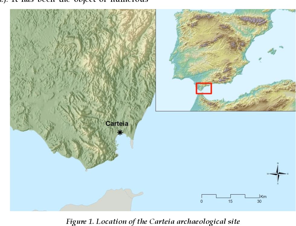
Carteia has its origins in the 4th century BC, when the inhabitants of the Phoenician settlement of Cerro del Prado, located inside the estuary of the Guadarranque River, moved to a new site about two kilometres away, on the coast of the Bay of Algeciras. Although it emerged under Carthaginian rule, during Roman times Carteia became one of the most important cities in Hispania.
For her part, the Izquierda Unida deputy and spokesperson for the parliamentary group Por Andalucía, Inmaculada Nieto, will present a series of initiatives to inquire in parliament about the problems of the archaeological site of Carteia in San Roque.
"It is unacceptable that one of the archaeological sites in the Campo de Gibraltar has been closed down, while the Junta de Andalucía (Andalusian regional government) is giving the silent treatment. We are going to take this situation to the Andalusian chamber to demand explanations and solutions", said Inmaculada Nieto about the situation created in the archaeological site in San Roque.
Nieto has committed herself to a series of initiatives with the aim of asking for explanations about the current state of affairs at Carteia, about the causes that have led to its closure and about the measures planned to recover its activity.
I've wanted to do an article about Carteia for awhile; and this might be a sign to look at all my notes and get something put together.
I just find it unacceptable that the so-called historians and archeologists in Gibraltar and the area refuse to accept that Teia Tephi was in fact in Gibraltar and accepted as queen before she was planted in Ireland.
This ruin isn't Roman; the Romans built on top of it. To me, it seems like even the coins at the time, printed in "Carteia", honored her, at least the memory of her.
"On their way back to Egypt the Tyrian ship sank and there were no survivors, which explains why nobody knew where The Ark went after it left Tanis or even that it had left Tanis. This was confirmed by Baruch who saw a vision of the ship sinking, immediately before his own death, passing away at the age of eighty and being buried at Caer Teia, Gibraltar." – A Brief Summary of Teia Tephi, queen of Gibraltar and Ireland.
They dethroned their idol Melcarth who they made graven images of; and made Teia their queen, giving her Melcarth trident.
Teia Tephi 7:2 Then said he, "No more Caer Melcarth, Caer Teia this place is named.
Our Rock hath shouted thy name. Therein shall its walls be famed,
Whilst the seed of David endures," but God's Prophet answered him, "Nay,
This too shall be broken in pieces, its stones be carried away.
Not once nor twice shall this be, by the land, by the seas, by the Strait
Shall the spoilers come with engines [of war] to storm the Tower of the Gate;
But at 'eve' returneth the damsel that holdeth the Trident spear;
In St. Michael's Cave, they shouted "Caer Teia".
How obvious does it have to be?
If Carteia comes in focus as with the article you shared, then maybe this history will come back to life.
The Junta makes improvements in Carteia and Verdemar says "they are lying to us".
"Carteia, open or closed? With staff or without? These are questions that citizens have been asking since Verdemar and Ecologistas en Acción reported the temporary closure of this archaeological site. The association claimed that the closure was due to the non-renewal of the tourist guide and the lack of personnel that this enclave suffers from.
However, the Minister of Culture, Arturo Bernal, responded to this media outlet by stating that the site "has been closed for four days to carry out cleaning and improvement work on the main visitation path. This path needs to be marked and some branches that hindered visits need to be removed."
In addition, Bernal announced that they are working on the incorporation of new personnel such as guides and interpreters. "In a few weeks we will have an increased staff. I understand that we are in an electoral period and we need to try to stir things up, but I think it is inconsistent because it highlights going against a figure and putting Carteia where it shouldn't be. We have just approved a project to renovate a part of the outer wall worth 26,000 euros," criticized the minister regarding the information published by the San Roque City Council and Verdemar.
On the other hand, Verdemar reported yesterday that Carteia remained closed to the public, something that the Andalusian administration denies. "It was open yesterday and it is open today. I think there has been an intervention by some local politician on this issue that is false," they indicate.
For his part, Paco Cervantes, from Verdemar, assures that "we have been following the daily progress and nothing has been done there. It is a total lie. Carteia did not open yesterday and I have photos of it. From Verdemar we say that the minister is lying."
San Roque plenary session calls for Carteia to be listed as an archaeological site
The full council of San Roque (Cádiz) has approved a motion to ask the Junta de Andalucía for Carteia to be listed as an archaeological site, which would mean "more budget and staff".
As reported by the Consistory in a note, the motion presented by the PSOE was approved with 14 votes in favour and the vote against the four representatives of the PP. Specifically, the measure received ten votes from the PSOE, two from San Roque 100x100 and two from Adelante San Roque and PIVG.
The motion urges the Andalusian Agency of Cultural Institutions, which depends on the Andalusian Regional Ministry of Culture and Sport, to "immediately" process the requalification of Carteia, so that it can be classified as an archaeological site.
This change would allow more budget and staff for the site, including a director, an archaeologist and a restorer, so that the necessary conservation work, archaeological cleaning and consolidation work and protection of structures and remains that make up the site can be carried out, as well as including it in the Performing Arts Circuit in which Baelo Claudia is included.
The approved motion also includes that the City Council should adhere to the proposal of the European Heritage Label for Carteia, which would further increase its degree of protection, and that all administrations should be urged to ensure that the site is kept open to the public "and with sufficient budget".
It also includes a request for the Andalusian Agency for Cultural Institutions to report on the closure of the Carteia archaeological site to the public for five days last week.
In this regard, it should be recalled that the Minister of Tourism, Culture and Sport, Arturo Bernal, explained a week ago that this site had been closed for several days because improvements were being made "to the path that is the main axis of the visit".
Bernal also announced that work was going to be carried out on a part of the wall of the forum "which has problems" and that work was being done to incorporate interpreters for visits to the site.
The archaeological site of Carteia, located in the municipality of San Roque, saw a 50% increase in visitors during the first two months of 2023, compared to the previous year. The space, managed by the Andalusian Agency of Cultural Institutions (AAIICC), is the first colony established by the Romans outside the Italian peninsula, after the Senate granted the title of Colonia Libertinorum Carteia in the year 171 BC.
The Minister of Tourism, Culture and Sports of the Junta de Andalucía, Arturo Bernal, visited the site on Monday, accompanied by the subdelegate of the Junta de Andalucía in the Campo de Gibraltar, Javier Rodríguez; the delegate of the Andalusian Government, Mercedes Colombo; and the territorial delegate of Tourism, Culture and Sports, Jorge Vázquez. During the visit, Bernal highlighted the relevance of this space as "a historic enclave and one of the main points of fishing activity in the area before and now, linked to salted fish and conserves, and the production of garum," he recalled.
In this regard, experts from the University of Cádiz are currently carrying out a line of work and research on this subject "not so much linked to the urbanistic vision, but especially to industry, linked to the industry and the product that defined this and other areas," Bernal added. The Minister expressed his satisfaction with the progress of this work and the effort of the professionals. "The teams are perfectly formed. We currently have seven people working at this site, in coordination with the technicians of the Cadiz university institution," he emphasized.
"Currently, two lines of research are being carried out in the forum area. One, of purely archaeological tasks, on a 42-meter-long wall," Bernal pointed out. On the other hand, he recalled that the technicians are working on the consolidation of a specific area of the land, after some landslides in a retaining wall, "to be able to maintain the prospection and archaeological work in the area, which is already very defined," the Minister reiterated, highlighting the "normality" in the overall Carteia.
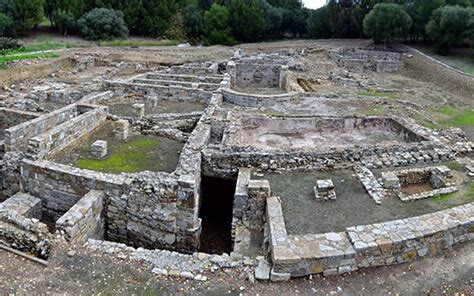
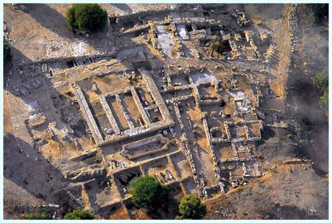
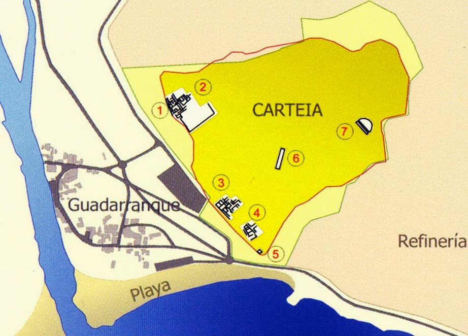
The archaeological site of Carteia is a vast expanse of land a few meters from Guadarranque Beach, where visitors can see a Punic wall, a Roman temple from the republican era, a basilical pool, a thermal building, several Roman houses or domus, a salting factory, and a large building from the time of Emperor Augustus, among other remains.
In addition, in contemporary times, during World War II, this space once again became relevant due to its geographical location. More than 500 military fortifications were built in this area as part of the Defense Plan of the Campo de Gibraltar, to guarantee the integrity of Spanish territory against a hypothetical allied attack from Gibraltar.
Specifically, three bunkers were built in Carteia that were never used in military action, although they were manned. One of them has been turned into a museum and opened to the public. It is a mixed nest with three rooms, equipped with machine guns and an anti-tank gun. One of the shooting rooms has been faithfully recreated. In the central room, the largest one, the landscape that could be seen from it in the 1940s is reproduced behind the gun slot, and various war utensils, plans, and photographs are exhibited. The third room has been stripped of its military character, and sociocultural aspects of postwar Spain are evoked in it, with graphic and sound resources, including a radio from the period.
Thus, the space remains open normally, responding to the growing interest in knowing this Cultural Heritage Site, which was a Roman colony near the Strait of Gibraltar. Specifically, Carteia opens its facilities from 10:00 a.m. to 2:00 p.m. on Wednesdays through Sundays. To arrange a visit, it is necessary to request it in advance. These tours are guided by personnel from the center, once the requesting groups have been formed. There are visits every hour at 10:00 a.m., 11:00 a.m., 12:00 p.m., with the last one at 1:00 p.m.
Verdemar considers the visit of the councilor to Carteia in San Roque "disappointing."
Verdemar-Ecologistas en Acción has criticized the visit of Arturo Bernal, the Culture Minister, to the archaeological site of Carteia in San Roque on Monday, calling it "disappointing for those of us who saw an opportunity in it." The group believes that the visit was merely "an act to silence the protests that the citizens of the Campo de Gibraltar have staged due to the clear neglect of the site by the responsible administration, the Junta de Andalucía, using arguments that do not convince anyone who looks beyond the surface."
Verdemar believes that "the situation of the former coordinator or coordinator, Francisco Alarcón, is not clear, as this point is poorly defined since he himself doubts what his role is at Carteia at present. However, the only thing he asserts is that the closure of the site that occurred a few weeks ago was due to the presence of branches and plant elements on the paths, when it is well known that this was a false excuse given by the Minister during his visit to Algeciras on the occasion of the inauguration of the Pérez Villalta exhibition on March 24, and has nothing to do with reality, which was the non-renewal of the contract of the guide of the site."
Verdemar also questions who will coordinate the hypothetical planning that the Minister mentioned, given that there is no one currently dedicated to the site's management, and whether it will be done remotely.
However, the group does celebrate the presence of the University of Cadiz, represented by José Ángel Expósito, who has illustrated their statements with the work they are carrying out in the pool area known as the Romantic Garden. Still, they note that, in their opinion, the University's presence is "testimonial," given that the intervention they refer to lasted only one week, an intervention that "obviously does not deal with the daily tasks of the site." They add that "tasks such as conservation, protection, prevention, dissemination, visits, as well as administrative tasks, are not part of any research project. That is to say, the security of the site is in no way guaranteed by research," they emphasize.
Verdemar also criticizes the Minister's comments regarding the local council, which they believe he was more interested in criticizing than in the future of the site. When asked about the possibility of changing the administrative classification of the site from an enclave to an archaeological complex, Verdemar believes that the Minister's response was confusing, and they do not agree with his statement that Carteia has a staff of seven people, as they believe that "a guard, a guide, and three workers (one of whom works part-time) only add up to five." In short, Verdemar considers the Minister's statements to be disheartening because they convey insecurity and a lack of knowledge about the reality of a site that involves all the problems of an area of nearly 30 hectares, which means constant activity in maintenance tasks, cleaning, prevention, consolidation, treatment of archaeological remains, etc., to speak only of conservation issues.
The Electoral Board dismisses the complaint by the PSOE about the technical visit of the councillor to Carteia.
The Provincial Electoral Board (JEP) has dismissed a complaint by the PSOE regarding the visit made by the Minister of Culture, Arturo Bernal, to the archaeological site of Carteia in the municipality of San Roque on April 24th, as they understand it to be a "technical visit" and the facts would not fall within the limits established in Article 50 of the Organic Law of the General Electoral Regime (Loreg).
In the resolution, which has been accessed by Europa Press, the PSOE recalls that during the visit, the councillor was accompanied by the delegate of the Junta in Cadiz, Mercedes Colombo, the sub-delegate in the Campo de Gibraltar, Javier Rodríguez, the territorial delegate of Culture, Jorge Vázquez, and the PP candidate for the Mayorship of San Roque, Daniel Rodríguez.
The PSOE requests "to require the authorities mentioned to refrain from attending events of an institutional nature in their capacity as councillors of the Junta and in particular to refrain from carrying out institutional acts in the company of members of electoral candidates. It also calls for the "removal of publications issued and the imposition of the corresponding fine."
Likewise, the Electoral Board has indicated that it understands that "the act corresponds to the ordinary functions of these political leaders who, during the electoral period, must continue with their political leadership duties." Additionally, it has added that "it may be considered a technical visit to the archaeological site, informing about objective data."
Regarding the publications on social media, the JEP has pointed out that they "belong to the PP candidate for the Mayorship of San Roque, to whom the complaint was not addressed, and who retweets what has already been published on the Government Delegation's website, adding some tags" to which JEP "cannot intervene ex officio".
The fishing activity (associated with the salted fish industry, the production of amphoras, and the export of salted fish, especially tuna) represented the most powerful and profitable of all the activities developed in the city and its surroundings, since the salted fish factories and pottery industries run by citizens of Carteia, rich and powerful families such as the Numerii, Vibii, and Minii, were located throughout the coastline from Villa Victoria (Puente Mayorga) to the Palmones River area: the Venta del Carmen pottery (Los Barrios).
Ancient sources are abundant in mentions of the fishing wealth and associated industries established in Carteia and other cities of the so-called "Strait Circle" in Roman times. Geographers, naturalists, and numismatic evidence abound with data relating to the variety and abundance of the products of the land, the generosity of the bay waters in species of fish and shellfish, and the industrial power around shipbuilding, fish salting, purple production, or pottery in the area. All of these economic activities were linked to an active maritime trade confirmed by the shipwrecks found in the bay waters, the remains of salted fish amphoras scattered throughout the Mediterranean and even in the Germanic and British "limes" from the local pottery workshops, as well as the coin findings of the local mint made in distant places that indicate the vigorous commercial activity that Carteia reached.
Numerous material testimonies have been recovered that demonstrate the economic importance that fishing and its industrial processing acquired in the Phoenician settlements of the western Mediterranean, with the Phoenician factory of Cerro del Prado being no exception. This factory was located next to the Guadarranque River and was active between the 7th and 4th centuries BCE. Fish, mainly tunas, caught using a technique known in the Andalusian period as almadraba or jábega, was processed on an industrial level in specialized coastal factories using salting methods to achieve its preservation and to allow it to be commercialized and exported by sea in ceramic containers that traveled to other places in the Mediterranean, the East, Britain or Germania.
Many classical writers describe the abundance of fish that were caught and the enormous wealth that fishing generated for the populations located on both sides of the Strait, both in the Phoenician-Punic period and in the later Roman period, as explained in the well-documented article "Archaeology of Fishing in the Strait of Gibraltar. From Prehistory to the End of the Ancient World" by Professor Darío Bernal Casasola. It is true that from the end of the Roman Republic, after the last Civil War - perhaps due to the support of the Carteians to the cause of Pompey, the loser in that war - there are very few written sources about Carteia. However, thanks to the production of coins and the texts of the geographer Strabo (1st century BC and 1st century AD) and the naturalist Pliny (1st century AD), we have revealing data regarding the fishing activity of the city.
Strabo states (Chapter III, 2, 7): It is said that in Carteia, buccinum and murex shells have been found that can contain up to ten kotilay (about three kilograms); and off the coast, moray eels and conger eels weighing more than eighty mnai (about thirty kilograms) are caught, as well as octopuses weighing a tálanton (about twenty-six kilograms), squids two cubits long, and so on. Many tuna fish that come from the Outer Sea to these coasts are fat and greasy. They feed on the acorns of a certain low-lying oak tree that grows near the sea, which produces truly abundant fruits...; however, they produce so many that after high tide, both the coast of the inner part and the outer part of the Pillars are covered with those that the tide brings in... And the closer the tuna fish come from the Outer Sea to the Pillars, the thinner they become, due to lack of food.
Pliny writes in his Naturalis Historia (Book IX, 92-93): Trebius Niger, from the entourage of the proconsul of Baetica, L. Lucullus, tells that there was an octopus in the ponds of Carteia that used to come out of the sea and approach the open ponds, ravaging the salted fish... which aroused the excessive indignation of the guards due to its continuous thefts. Fences protected the place, but it climbed over them by climbing a tree; it could not be discovered except by the sagacity of the dogs, which saw it one night when it was returning to the sea. The guards were amazed at the spectacle, first because of the size of the octopus, which was enormous; then because it was completely covered in brine, emitting an unbearable odor... It frightened the dogs away with its terrible breath, sometimes whipping them with the ends of its tentacles or striking them with its very strong arms, used like clubs. It was only with great effort that it could be killed with tridents. Its head, which was the size of a dolium capable of containing fifteen amphoras, was shown to Lucullus; repeating the words of Trebius himself, I will say that its beards could hardly be encompassed with both arms and were knotty like clubs, with a length of thirty feet. Its suction cups were like pitchers, resembling a basin; the teeth were of the same proportion. The rest of the body, which was kept for curiosity, weighed seven hundred pounds. The same author asserts that on these beaches, the sea also throws cuttlefish and squids of the same magnitude.
Both texts reveal the importance of fishing and the industrial process of preserving fish products in cities located on the shores of the Strait. Strabo likely obtained the data from Posidonius, who was on the coasts of Gades at the beginning of the 1st century BC. The Greek geographer extensively describes the abundance and quality of the fish that inhabited the waters of the Fretum Gaditanum, alluding to a species that has been the basis of fishing and the fishing industry on both sides of the Strait since prehistoric times: the bluefin tuna (Thunnus thynnus).
Although Pliny's account, which describes a giant-sized octopus, is fantastic, it is still of special interest for the knowledge of the exploitation of marine resources in the city of Carteia, as it mentions "cetarias" (pools) where pieces of tuna were placed in brine for maceration, which have been documented by archaeology in Carteia, Iulia Traducta, Baelo Claudia, Mellaria, etc.
In addition to the architectural remains and other movable materials, numerous bronze hooks have been recovered in the excavations carried out in the city of Carteia. In a work carried out at the Acerinox factory (Los Barrios), a fish plate was found and is currently preserved in the Municipal Museum of Algeciras.
Regarding the arts and methods of fishing, in Carteia, as in the rest of the cities of the Mare Nostrum, a wide variety of methods and different arts were used to catch fish, cephalopods, crustaceans, and mollusks. Although there are no mosaics with representations of fishing scenes in the coastal cities of Bética, numerous mosaic testimonies from the 2nd and 3rd centuries AD are exhibited in the Bardo Museum in Tunisia, which allow us to know the various fishing techniques used in Roman times. Individual fishing with a cane, harpooning cephalopods with tridents, the use of traps, seine fishing, cast nets, and the jábega are documented. The gathering of limpets, snails, and periwinkles is documented by the presence of the shells of these mollusks in the excavated sites in Algeciras (Iulia Traducta, on San Nicolás Street) and Baelo Claudia. Recently, a purple production workshop has been located in the extramural area of Carteia (Villa Victoria, Puente Mayorga), with a large shell mound where remains of nineteen species of malacofauna have accumulated, dated to the 4th century AD.
A preserved salting factory was excavated on the site of Villa Victoria (San Roque) (E. García Vargas and D. Bernal Casasola).
The importance of fishing and the industrial process of preserving fish products in the cities settled on the shores of the Strait is revealed in both texts. Strabo likely obtained the data from Posidonian, who was on the coasts of Gades in the early 1st century BC. The Greek geographer elaborates on the abundance and quality of the fish that populated the waters of the Fretum Gaditanum, making reference to a species that, from prehistoric times to the present day, has been the basis of fishing and the fishing industry on both sides of the Strait: bluefin tuna (Thunnus thynnus). Although Pliny's account, which describes a giant-sized octopus, is not without its fantastic elements, it is still of special interest for understanding the exploitation of marine resources in the city of Carteia, as it mentions the "cetarias" (fish tanks), in which pieces of tuna were placed in brine for maceration, and which have been documented by archaeology in Carteia, Iulia Traducta, Baelo Claudia, Mellaria, etc...
Excavations carried out in the city of Carteia have yielded, in addition to architectural remains and other movable materials, numerous bronze hooks. In a project carried out at the Acerinox factory (Los Barrios), a fish plate was found and is now kept at the Municipal Museum of Algeciras.
Regarding fishing techniques and methods, a wide variety of methods and different techniques were used in Carteia, as in the rest of the cities of the Mare Nostrum, to catch fish, cephalopods, crustaceans, and mollusks. Although coastal cities in Bética do not have mosaics with representations of fishing scenes, the Bardo Museum in Tunis displays numerous mosaic testimonies from the 2nd and 3rd centuries AD that allow us to learn about the various fishing techniques used in Roman times. Thus, individual fishing with a cane, harpooning of cephalopods with tridents, the use of traps, fishing with nets, throw nets, and the jábega are documented. The harvesting of limpets, snails, and winkles is documented by the presence of shells from these mollusks in excavated sites in Algeciras (Iulia Traducta, in San Nicolás street) and Baelo Claudia. Recently, a purple production workshop has been located outside the walls of Carteia (Villa Victoria, Puente Mayorga), with a large shell deposit that accumulates remains of nineteen species of malacofauna, dating back to the 4th century AD.
One cannot fail to mention the coin emissions of Carteia, which depict images related to the marine world and fishing to demonstrate the importance that the exploitation of sea resources had for the city. On the reverse of some coins, a fisherman with a cane and a basket for depositing catches, dolphins, ship's prows, a rudder, etc., are depicted. Dolphins, which symbolize navigation and were protective for ships, also appear engraved on Roman lead anchor stocks recovered from the waters of the Strait. The figures represented on the coins had, in addition to their nominal value, the function of capturing prominent aspects of political, social, or religious life, as well as exposing and advertising the images that represented the most prominent economic activities of the city, whose diffusion was directly related to the commercial boom of Carteia society, and therefore can serve as an element of analysis to understand the development of Carteia, its economic potential, and the geographical projection of its economy.
Carteia, a footprint of the Roman Empire in the Campo de Gibraltar.
Starting from the 1950s, the Cortijo de Rocadillo in San Roque became the setting for archaeological excavations that gradually uncovered the city of Carteia, a Roman colony founded by the Phoenicians and developed by the Carthaginians, which disappeared in the early Middle Ages.
Located at the mouth of the Guadarranque River, Carteia was already mentioned in Greek and Latin writings before the archaeological remains were found, as stated by National Geographic. The city, overlooking the Strait of Gibraltar and the African coast, occupied a strategic position and engaged in activities such as fishing, salting fish, and pottery.
During the 18th century, drawings and engravings depicting Carteia showed remains of a theater, city walls, and a wharf, which served as the basis for the excavations.
Numerous coins, inscriptions, and other artifacts have been found in the site, including the "huerto del gallo" in 1840, the so-called "marble board" with reliefs of ox skulls (bucrania) and garlands, as well as a strigilated sarcophagus (decorated with symbols in the shape of 'S') discovered in 1927, which is currently preserved in the Museum of Cadiz.
Visitors can currently explore a Punic wall, a Roman temple from the Republican era, a basilical-plan swimming pool, a thermal building, several Roman "domus" (residences), a salting factory, a large building from the time of Emperor Augustus, several Late Roman necropolises (6th century AD), a Roman theater, the Rocadillo Tower (a 16th-century coastal watchtower commissioned by Philip II), and a World War II bunker.
Verdemar Ecologists in Action has alerted the Territorial Delegation of Tourism, Culture, and Sports in Cádiz about the "emergence of possible archaeological remains from Carteia due to the movement of heavy machinery."
As stated in a press release, these emergences result from the construction works for the sanitation and purification project in San Roque and other municipalities in the Campo de Gibraltar (Cádiz).
They have specified that in the movements of heavy machinery, "possible remains of the city of Carteia are appearing, which we want to be studied."
Finally, they have reminded that "regulations dictate actions in a catalogued area; however, if archaeological remains were discovered in any operation, the process would immediately be halted, and the study and cataloguing of the findings would proceed."
Verdemar points out that new remains of Carteia have emerged in Guadarranque.
Verdemar Ecologists in Action has reported to the Territorial Delegation of Tourism, Culture, and Sports in Cádiz the emergence of possible archaeological remains of Carteia due to the movement of heavy machinery.
These emergences are a consequence of the works being carried out for the construction project of sanitation and purification in San Roque and other municipalities in the Campo de Gibraltar (Cádiz).
Possible remains of the city of Carteia are appearing in the movements of heavy machinery, which we want to be studied. Regulations dictate actions in a classified area; however, if archaeological remains are discovered in any action, the process would immediately be halted, and the study and cataloging of the remains would proceed.
Verdemar Ecologists in Action criticizes the use of large excavator shovels knowing that archaeological remains exist; specifically, they may have damaged the pools. This pipeline could have gone elsewhere, as there are studies on these archaeological sites in Carteia.
For Verdemar Ecologists in Action, it is regrettable the little concern that the San Roque City Council (Cádiz) is showing in this work next to this Roman city of Carteia.
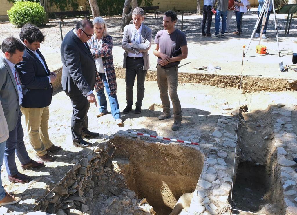
Archaeological excavations in the salting workshops of the romantic garden of Carteia (I)
In this work, we present the first results of the excavation campaign that we carried out throughout 2022 in the so-called "Romantic Garden," located within the limits of the Archaeological Site of Carteia (San Roque), where the most prominent visible remains associated with the production of sauces and fish salting in Carteia are located.
This excavation campaign is the result of collaboration between the University of Cádiz, the Autonomous University of Madrid, and the management of the Archaeological Site of Carteia, and is part of the Scomber Project, aimed at tracing the origin of Roman salting productions on the Cadiz coast, of which this activity represents the first step.
In the site we analyzed, three salting workshops (cetariae) were partially visible, of which limited information was available, as we will refer to later. Only recently, the development of a doctoral thesis by J. A. Expósito focused on the study of the Carteia fishing industries, developing new interpretative approaches, although without carrying out excavations. Therefore, we considered it necessary to carry out new surveys that would help us to date and evaluate the significance of these testimonies, which are the only ones related to this productive activity found within the visit circuit of the site.
Excavations by Julio Martínez Santa Olalla
In the 1950s, the first scientific excavations took place in the city of Carteia, carried out by the then General Commissioner of Archaeological Excavations, Julio Martínez Santa Olalla. The first evidence of the city's canning industries was unearthed in them, previously known only from textual sources and numismatics.
The photographic documentation of those works is currently preserved in the National Archaeological Museum as part of its legacy, which was acquired, after his death in 1973, by the Ministry of Education and Science, and remained virtually unpublished until 2004. The absence of publications, and even the disappearance of his excavation diaries or original manuscripts, have made his photographic corpus an essential document to know and characterize the excavations carried out and obtain direct information about the buildings excavated. We can also assess the methodology employed, technical applications, use of photography, etc., through them.
Based on this interesting legacy, we have been able to verify that, among other actions, excavation work was carried out in a large sector between the stretch of wall documented to the southeast of the city and the coastline line located in suburban areas. Some photographs show the legend "Carteya. Beach Gate. 10-XII-59," confirming the place of realization and the date on which said work was carried out.
The excavations allowed the exhumation of several salting pools in which, through the images, their characteristics and constructive form can be observed. It is an area with four documented pools of small size and rounded corners, lined inside with the characteristic high-quality hydraulic concrete. These data have been corroborated both by the subsequent cleaning and documentation work carried out in this sector in the early years of this century, and in the excavations that we present here.
The salting workshops and the 2022 campaign
As we have pointed out, the previous knowledge of the cetariae visible in the Romantic Garden was very limited. The workshops were arranged in an area limited on its northern side by walls surrounding the pools, with a preserved door that would give access to the salting enclosure, the so-called "beach gate."
In this location, we were able to distinguish the existence of three independent production units, but they shared master walls and a very similar internal structuring, highlighting both the even module of the pools and their own cadence and arrangement. These three salting workshops, which we enumerate as cetariae C-VI, C-VII, and C-VIII, were partially excavated, with the central one (C-VI) being the most visible, with up to seven apparently structured salting pools in two wings. Of the other two factories, located to the east (C-VII) and west (C-VIII) of the former, the data were more limited, with only three tanks visible in each case. Of these, the only fully visible (and excavated) tank is P-1 of C-VII, which provided us with initial data on which to make the first estimates of the productive capacity of these workshops, which for C-VI would exceed 32 m3.
From an architectural point of view and approaching dating criteria, we must note that these structures were made - as is usual in other constructions in the city - in opus vittatum, which evidences the remarkable care of the construction. The masonry is characterized by the use of limestone masonry arranged in regular rows, with the corners of the walls finished with sandstone ashlars. It is a construction technique well documented in other buildings in the forum area, which can be traced back to the late Republican period. However, the additional use of sandstone, noted in the basilica, suggests a slightly later period, as it was introduced in the time of Augustus. In another line of analysis, looking at the few surface ceramic contexts associated with these productive buildings, we were able to confirm the presence of limited amphora remains deposited on one of the walls of cetaria C-VII, which corresponded to parts of Dressel 7/11 and Haltern 70 amphorae, which referred to a timeframe between the Augustan period and the late 1st century AD, so we estimate that this sector of the industrial quarter should have been in operation, at least at an early stage of the early imperial period.
These testimonies confirmed the presence of salting production structures, but they were partial, could not be accurately dated, and did not provide data on the fishing productions carried out. To try to solve these shortcomings and answer these questions, being aware of the problems expressed here, in September 2022 we proposed the first excavation campaign in this sector of the Carteia industrial quarter. Specifically, we designed the realization of two archaeological sondages in addition to a third zoning in which only contemporary levels were removed (sheet 4), with the aim of assessing the level of affectation of Santa Olalla's excavations in the southern sector of this edifice agglomeration and complete the necessary documentation to date and interpret this sector of the productive district of Carteia correctly.
Sounding 1
The first of the sondages was designed with dimensions of 31.5 m2, covering the entire known surface of cetaria C-VII. With this action, we intended to advance in the delimitation of the building, carry out a complete diagnosis of its architecture, identify the different environments functionally, and analyze the fillings of one of the pools, located next to the previously excavated P-1, to compare them, date their initial abandonments, and look for residues of their last productions.
With these premises, we observed that the general stratigraphy was sealed by contemporary fillings associated, on the one hand, with recent regularizations and gardening in this sector, and on the other hand, with the excavation carried out in the mid-20th century by Santa Olalla, immediately under them being the stratigraphy and structures of the classic era associated with the fishing productions, with a good level of general preservation.
It is striking in this regard that in the two soundings carried out, the presence of an extensive generalized trench that cut obliquely through the Roman structures and stratigraphy in an east-west direction has been confirmed, with a length of more than 16 m and a wide width, whose southern end we have not yet documented, and which could perhaps be associated with the performance of accessory works or entrenchments related to the construction of the contemporary bunker located a few meters following the direction marked by the trench.
Under these recent fillings, we were able to document the presence of several levels of infilling covering the space occupied by the work rooms that we identified to the northeast and southeast of the sounding, which could be dated between the mid-1st century and the 2nd century AD, based on the recovered materials where high imperial lamps and amphorae are present, which, although they are still being studied, are clearly situated in this chronological framework, thus defining an early moment of definitive abandonment of the space, without any late Roman phase evidence being observed between the high imperial and contemporary sequence.
The work focused especially on the excavation of one of the exhumed tanks (P-2), which could be excavated completely, providing the most significant data of the entire stratigraphy. Inside, we were able to attest, first of all, to the collapse of the roof that sealed the lower filling with a clear deposit of construction material, highlighting the tegulae and imbrices. Under this collapse, we documented several levels of sandy deposits characterized by the integration of the dumping of a large number of amphora containers, consisting of more than twenty individuals, a large part of which presented an exceptional level of preservation. For the most part, these fillings consisted of Haltern 70 and Dressel 7/11 amphorae, which again refer us generically to a horizon similar to that offered by the upper filling, showing that the process of filling the tank and the final filling of the building was very fast and close in time.
Regarding the moment of initial abandonment, under the mentioned dumps, we documented the basal levels of the sequence, identified as eolian deposits of clean sands, which indicate that possibly the tank was abandoned empty, without any primary residues that could inform us about the last productions elaborated there.
Verdemar-Ecologistas en Acción asks the Andalusian Government to explain why Carteia is still without electricity and abandoned.
We denounce that the city of Carteia from the year 171 B.C. , the first Latin colony outside of Italy, is doomed to anarchy.
We continue to insist that this archaeological enclave has been in decline for years and must be recovered. We urge all neighborhood associations and movements to mobilize to demand greater protection for Carteia from the Andalusian government and the San Roque City Council.
We understand that the Junta de Andalucía must assume that Carteia has been deteriorating for years, without human resources, with signs of its annihilation.
Following the construction of the Cepsa refinery in San Roque, remains of the disappeared city began to appear and since then it has not been treated with the recognition it deserves, in fact, it has always been treated with indifference, submerging it in oblivion.
The Junta de Andalucía does not respond to any of the complaints and requests from Verdemar-Ecologistas en Acción, there are many abuses and Cultura remains silent. We have no choice but to use other resources.
Verdemar to Denounce European Funds Allocated for the Conservation of Carteia
The conservationist group Verdemar Ecologistas en Acción announced this Sunday that it will file complaints about the expenditure of European Union funds provided through the European Regional Development Fund for the Planning of Access and Parking for the Carteia Visitor Center in Guadarranque, San Roque.
Verdemar reminds us that the Ministry of Finance and Public Administrations and the Provincial Council of Cádiz participated in this project. However, the ecologists note that the city of Carteia "remains abandoned."
For the conservationists, "the state of the Carteia Visitor Center, which was built with European Funds and subsequently abandoned without even being inaugurated, is lamentable. Rust is corroding everything, and the panels are rotting inside the site, which is invaded by construction material debris," they emphasize.
Verdemar has also reported the fire risk in the area, without any response from the Junta de Andalucía.
They recall that the city of Carteia, dating back to 171 B.C., is the first Latin colony outside Italy and is "headed towards anarchy."
"We continue to insist that this archaeological site has been in decline for years and must be recovered. We urge all associations and neighborhood movements to mobilize to demand greater protection for Carteia from the Andalusian government and the San Roque City Council," they stress.
Verdemar believes that the Junta de Andalucía "must acknowledge that Carteia has been deteriorating for years, lacking human resources, and is on the verge of annihilation."
Following the construction of the Cepsa refinery in San Roque, remains of the lost city began to appear, and, according to Verdemar, "since then, it has not been treated with the recognition it deserves. On the contrary, it has always been treated with indifference, consigning it to oblivion."
They insist that "the Junta de Andalucía does not respond to any of Verdemar Ecologistas en Acción's complaints and requests. There are many abuses, and the Culture Department remains silent. We have no choice but to use other resources."
Carteia (San Roque, C´adiz, Spain) is one of the main ancient cities in the Iberian Peninsula, and sits in a major geostrategic space: the strait of Gibraltar. With Phoenician origins, it achieved a prominent role as a Punic city and later on...
The architectural reality of an early Roman city such as this one, sat over the preexistent Punic city, allows us to reflect on the urban design and the occupation of city spaces through-out the various chronological periods during Antiquity.
What would the archeologist do if they recognized its Biblical Roots - Prior to the Romans? Perhaps, they'd protect the place better than they have done.
From JAHTruth:
Phoenicians/Israelites (but not Jews) sailed from the Middle-East along the Mediterranean to Gibraltar which was inhabited by Phoenician/Israelites from the "lost" tribe of GAD(please study my "Gibraltar - British or Spanish?" Booklet for details) , then through the Straits and across the Atlantic AT LEASTSIX CENTURIES before the "Virgin" birth of Jesus in Bethlehem.
The Phoenicians were the only sea-farers to pass through the straits, which they controlled and guarded, fiercely fighting to prevent competition. They also told people that if they went through the straits they would fall off the end of the world.
Spanish Propaganda - another Commonly-held Misconception
Gibraltar's Flag, which originated as the Ensign of the Phoenician/British /Israelite Tribe of Gad ; who was Jacob/Israel's (Gen. 32:28) eighth son (Gen. 30:11) and was Brit-ish not Jew-ish (Judah/Jew-dah -ishwas Jacob'sfourthson and one ofGad's half-brothersnothis dad) ; has sadly been deprived of its best colour - The Ruler of The Universe 's colour - the colour blue, and He is definitely not amused by its removal (because He considers it to be aninsultto Him andHisSovereignty of heaven - The Universe. To find outwhy, please continue reading) . The very first inhabitants of Gibraltar, since the Creation of Adam, were NOT Spanish they were Brit-ish Gadites who arrived between 1500 and 1000 B.C. and were later joined by more Gadites in 722 B.C. , the latter-arrival being recorded in the Gibraltar museum as Phoenician.
On the stone to the right of the Phoenician / Tyrian ship is shown a "return sign" that does not reach all the way back to Tanis, because, once the ship had left Gibraltar on its way back to Egypt, it sank with no survivors, so that the crew, who were evil and had planned to kill Jeremiah and his companions, could not tell anyone where they had gone, or even that they had gone from Tanis. - Jeremiah The Prophet's tomb
Prior to the De Danaans were the Nemidhians (Sons of Heaven) who came from Carthage which was a Phoenician Danite settlement or Sanctuary (Nemidh), in what is now Tunisia. The Phoenician sailors of ancient history (Phoeni - Feni)) were mostly Israelites from the tribes of Dan; Gad and Simeon. Phoenicia was a region not a country, just as Europe is a region and not a country. Welcome to a Unique Sociological Event.
The mayor of San Roque, Juan Carlos Ruiz Boix, has responded to statements made by the Junta de Andalucía regarding Carteia, denying that there has been any request for a construction permit from the Junta to resolve the electrical issue at the Archaeological Site.
Ruiz Boix accuses the Junta of negligence, as the electrical failure occurred 8 months ago during Storm Carlota, and since then the Junta has not provided an effective solution to the problem, only installing a portable generator.
For this reason, the mayor believes that "the Junta has intentionally abandoned Carteia, leaving it in the ICU," he quipped, "due to a lack of maintenance, conservation, and personnel."
The mayor expects the Junta to answer "three simple questions." First, he asked why there is still no electrical supply, which was lost almost 8 months ago in February during Storm Carlota. Since then, the Junta has supposedly been preparing a request for a construction permit to restore or recover the supply.
"Today, we read in the newspapers that the Junta claims Carteia has power via generators and is waiting for the San Roque City Council to approve a new electrical project," he stated.
The mayor pointed out that "the City Council cannot approve a project that has not been submitted, which is non-existent. As of October 1st, nearly 8 months after the power was lost, the Junta de Andalucía still hasn’t had time to submit the request for the new electrical project. Of course, the City Council will fully cooperate and immediately grant the permit once they do."
Secondly, he mentioned that in 2022, the City Council, in the spirit of institutional cooperation, had been investing in improvements at the archaeological site, particularly in a project to enhance the parking area and build a visitor center. This project involved a municipal investment of over 130,000 euros but was halted by the Junta de Andalucía in the summer of 2021, instead of cooperating.
Ruiz Boix stated that the City Council submitted objections to the halt, but since March 2022, more than two years later, the Junta has not responded.
In this case, the mayor pointed to a "hidden agenda" by Juan Manuel Moreno Bonilla to close the Carteia archaeological site, an issue the City Council, along with various groups and local residents who value the site, had denounced some time ago, citing the Junta’s gradual reduction of staff until almost all were eliminated.
The mayor added that, in 2023, the San Roque City Council debated a third issue in a plenary session. “If they care so much about the site, let them prove it. Therefore, we proposed that Carteia should be upgraded from its current designation as an archaeological site, which comes with lower personnel, maintenance, and conservation requirements than it actually deserves and needs. We passed a motion, supported by the PSOE, unfortunately opposed by the PP councilors of San Roque, for Carteia to become an archaeological complex.”
According to the mayor, this would allow for more budget, more personnel, including a director, an archaeologist, and a restorer—"essentially, the staff needed for an archaeological complex like Carteia."
It would also lead to more conservation work on the structures and cleaning of the site's remains. “Additionally, we wanted to open the doors of the complex even more, which is why we also requested at that time that the Andalusian Agency for Cultural Institutions include the site in the circuit of the Festival of Performing Arts of Andalucía, which has not been done,” Ruiz Boix recalled.
The mayor emphasized that "this is where the government of Moreno Bonilla’s Junta de Andalucía should focus, not on the press, lying and misleading the public by claiming that the City Council of San Roque needs to approve a project that doesn’t exist."